We did two club rides this weekend, Stephen’s first installment of the Fall Climbing Series and our own Flat Earth Society ride down the Iron Horse Trail, and what a pair of opposites!
The heat wave that ended today was forecast to end by Friday. Wrong! Friday was another 90+ day. The only sane ways to survive these conditions is either not to ride, ride indoors, or ride early in the morning. Even riding early we’d get home midmorning and it would already be in the 90s. Since this was the Nth grueling heat wave of the summer over in Contra Costa, we had the brilliant idea to go to San Francisco to get relief from the baking hence Stephen’s ride. What a difference! Saturday it was breezy, 60F, and completely overcast in SF. I was in knickers, long sleeved jersey, and vest for a change.
I was sort of looking forward to cycling in the City. I lived there for many years and even after decamping for Contra Costa I was still commuting to work in SF by BART/bike and continued to ride until I left my job there permanently in 2011. Since then I’ve only very infrequently done a club ride that started in SF, usually the Jersey Ride. Everyone who has lived and cycled in SF has their own routes and preferred places to ride and there is more diversity in riding in the City than one would believe. It’s not all city and even the heavily urbanized parts have their quiet and pleasant neighborhoods. What would it be like to return there after a very prolonged absence?
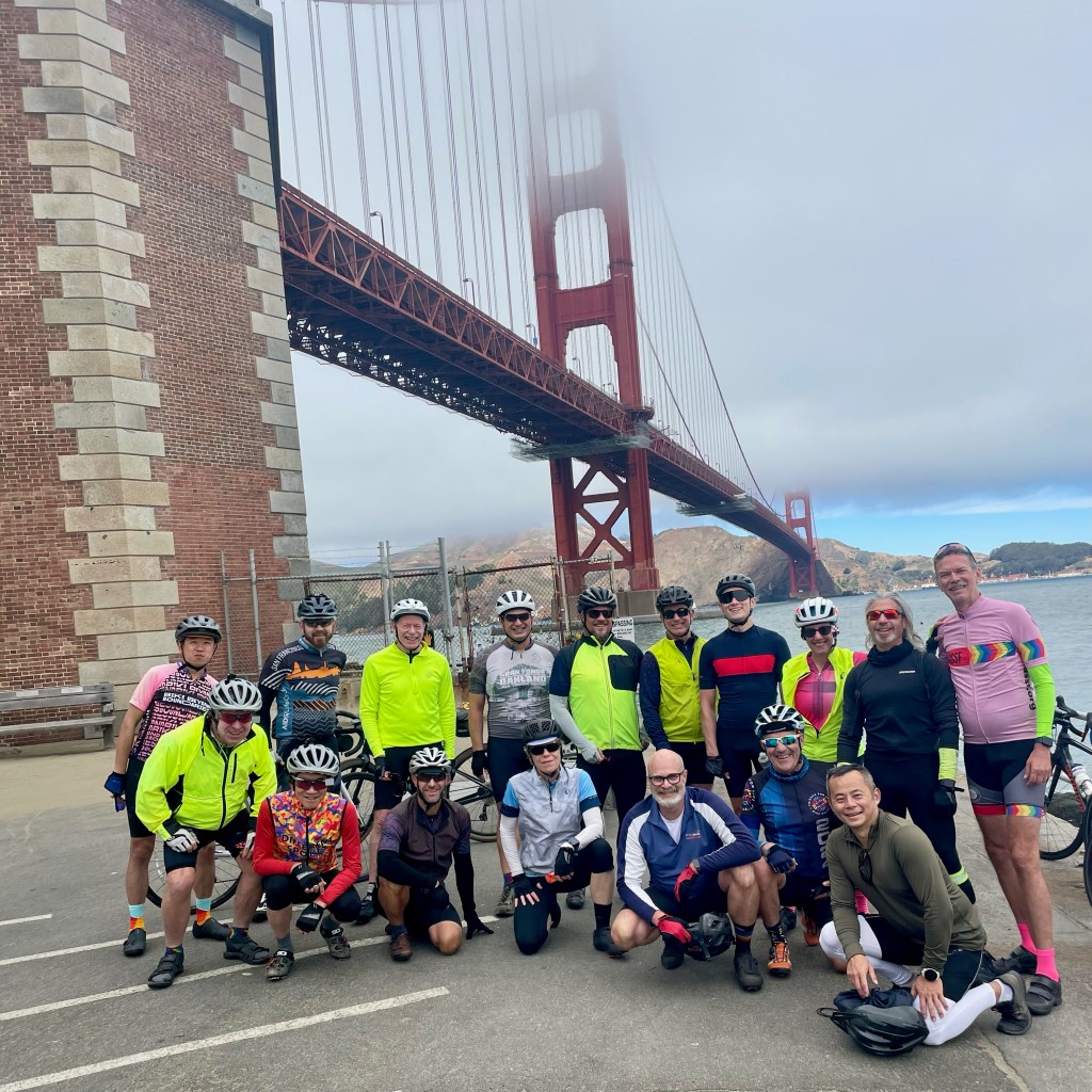
Stephen’s first Climbing ride was relatively easy: a loop from Peet’s to the Bay, up around the Embarcadero to Fort Point, and then drop down the Great Highway with the only big climb, up Twin Peaks, a route Stephen says he’s done a zillion times. If you live in the City you’ve probably done it or something very much like it many times. But familiarity doesn’t always breed contempt: the turnout was unexpectedly high, 17. By Different Spokes standards that is a very large group. A “large” turnout for our small club is anything north of 7 or 8. But since the majority of members live in SF, a City ride is very convenient and perhaps that was one of the reasons for the unusually high turnout. (The other is obviously Stephen’s fabulous personality. Oh yeah, and hotness! That queen sports only the most fab cycling kit possible.)
Stephen took us east through the Mission and lower Potrero all the way to Mission Bay, a route involving lots of traffic, lights, and nervous behavior. Despite the cool and overcast, people were out in droves by foot, car, and bike/scooter. He had us stop at La Stazione near Caltrain just so he could get his espresso fix and to give his delayed route orientation. The ride through Mission Bay to the Embarcadero was surprisingly easy because of all the “new” bike infra since I was last there. Protected bike lane? What will they think of next! Having ridden very little there since 2011 I was pleasantly surprised at how well it works in SF. Whether there are fewer car/cycle crashes and fatalities is another question though. But at least it looks nice.
Cycling in the City versus Contra Costa is a different sport altogether. Friends from outside SF think that cycling in the City must be very dangerous—all those cars! Yet all those intersections with stop signs and lights mean that speeds are generally lower whereas in Contra Costa long stretches without any speed mitigation mean higher average velocities and deadlier car-bike collisions. I admit that after a long hiatus from any intensive cycling in SF I was nervous. What an irony! The level of traffic density and distractions is high; it’s not just cars and trucks but also errant peds and rampaging scooters “coming out of nowhere”. In the suburbs people don’t walk. Except to their cars.
What’s with all those stop signs? Cyclists in SF seem to deal with them by ignoring them altogether. I thought I was in a weird city crit: the group rolled through stop signs like buttah. Because I’ve become a traffic nazi and having a healthy respect for tons of steel I stopped at Every. Friggin’. Stop sign. I had to sprint repeatedly just to hold the group in sight. I got my workout! Poor David Millard, who had volunteered to sweep, kept waiting for me until I told him not to. I certainly worked up a sweat playing catch up most of the morning. But it’s all about how you frame the situation, right? Practicing track stands, popping a sprint, hunkering down on the drops—it all makes you a better cyclist.
Save Madeleine??
I thought routing us through the Embarcadero and Fisherman’s Wharf was cheeky. It was of course hella busy on a summer Saturday morning with tourists and locals out enjoying the sights and I didn’t know which way to look to avoid the next near-collision: peds crossing the protected bike lane to their cars; pedicabs; Lyft cars picking up or dropping off fares. All that was missing was an elephant seal in the street for us to bean. It stayed more or less that busy all the way to Fort Point, another tourist hotspot. We regrouped for the obligatory group shot. No one did a Kim Novak imitation by jumping into the sea a la Vertigo. But I could tell that some were thinking about it but had forgotten to bring the flowers and opera gloves. After visiting the tea room, it was off for the first real climb of the day: Park. This short climb in the Presidio used to be part of an interval workout I did regularly when I was younger. It’s short, maybe a third of a mile, which is perfect for hill intervals. Ostensibly Stephen routed us this way to avoid traffic but the steepityness fit the point of the ride. Then it was up the next climb to the Palace of the Legion of Honor where I took it slow as well as up Clement. Down Ocean Beach for another tea room and then over to Java Beach for the next caffeine stop. The only thing left was the climb up Twin Peaks.
People left Java Beach in dribs and drabs slowly heading up to West Portal. I used to ride a lot in the Sunset because it was on my way to and from work. I also had time to kill after work since in those days you couldn’t get on BART downtown with a bike until after 6:40 PM. It’s a chill neighborhood with little traffic and lots of pleasant bike-friendly streets. No one is in a rush. Heading east is a gradual stairstep climb with a few short, steeper grunts before arriving at West Portal. There we took Ulloa to the top of Portola. Stephen warned everyone that Ulloa was “fuckin’ steep”. That wasn’t my (dim) recollection but my Garmin hit 14% near the top, so perhaps he’s right. It didn’t seem steep when I was young…
We caught up with the group at Twin Peaks Boulevard and Brian Midili just had to wind it up to get to the top first. He sure puts out the watts. Roger and I held his wheel but I wasn’t about to go around him into the howling wind. Kudos to Brian for upholding the Different Spokes animal tradition: dash and smash. Slowly riders trickled up to the top of Twin Peaks while we huddled against a dumpster to avoid the freezing gusts. Our preplanned photo op was a bust with the marine layer blanketing the town. At that point folks more or less went their separate ways down to their homes, an anticlimax of sorts to a pleasantly cool ride. We coasted back to the Castro in absolutely horrendous traffic. Is it always that way on weekends now?
Chill ride. Maybe too chill!
Overall it was a good way to start the Climbing Series with a challenging-but-not-too-challenging set of climbs and a big crowd to share the fun. I’m still mulling over the changes I saw in SF. It’s definitely more congested, which makes sense because when I lived there it was about 750,000 and now it’s way over 800,000. That’s a lot more people! I’m sure that if I were living in SF, I’d get used to the more frenetic traffic particularly east of the Castro. It’s a different kind of cycling. In Contra Costa there is more open space, longer roads without lights or stop signs, and a lot less people and the result is that I no longer care for the urban kind of cycling that I used to do every day. Or at least I’m no longer inured to that kind of cycling!
They was a-splishing and a-splashing/Reeling with the feeling/Moving and a-grooving/Rocking and a-rolling, yeah —Bobby Darin
This year’s Orinda Pool Party and Ride continued a distressing trend from last year, namely the dwindling number of actual riders, just six. Oh, the Pool Party had a healthy number in attendance and showed no sign of declining interest. But those willing to grind up Pinehurst and Skyline on a fabulous 29-mile loop before the party was small. “Back in the day”, i.e. pre-Pandemic, the riders way outnumbered the non-cycling attendees, the latter usually comprised of significant others, i.e. “the bike widows”. Now we’re in a new era in which cycling is an afterthought to mojitos by the pool and having your brunch served to you al fresco. The profuse lack of biker tanlines amongst attendees was a sure sign that the Apocalypse has come. Peak cycling is well and gone and even Spokers are content to idly spend their afternoons reposing rather than chasing each other on wheels. The porch dogs are nigh. Sigh.
No matter. We had a mahvelous time!
We had checked the BART schedule weeks beforehand knowing that BART has a nasty habit of shutting down weekend service to Orinda—why is this section of track always affected??—and set the date for the OPP to August 18 in order not to coincide with BART’s plans. Unfortunately BART decided at very short notice to delay a planned service closure by one week and it now coincided with our event, causing us at late notice to have to postpone the OPP until August 25. Proving that no good deed indeed goes unpunished—at least by BART—that morning it had yet another one of its countless snafus killing service through Oakland and delaying trains to Orinda. (Side note: And why are we throwing more money at BART for service like this??)
Carl and Roger both got caught in the mishegos and arrived late. At BART we waited patiently for their trains to arrive. We delayed the start just long enough for Carl to deboard and join but Roger was still stuck in another train behind. So off the group went while I waited for Roger to take his clothing and food. He arrived on the next train and zoomed to catch up with the group.
Meanwhile back at the manse Roger and I hustled to get the pool and food ready. This year’s brunch was a riff off of last year: smoked pork ribs, pesto pasta, a green salad, and a vegan brown rice salad. We ditched the Impossible burgers and vegan pesto in favor of some vegan barbecued riblets. Oh, and we added gluten-free pasta too. Whew. Roger’s skillz with smoking continue to refine and improve every year; he was the master at work! To add some amusement to the pool, we got some inflatables for loungees to repose upon and they were a hit. Next year’s request is for a hunky cabaña boy to serve food and drinks poolside and, uh, give “backrubs”. (Don’t hold your breath.)
Since most folks drove over we barely managed to squeeze all the cars into our driveways and not park on the street so our neighbors wouldn’t show up with pitchforks. David and Chris came despite having just returned from the South land; Peter made his way up from San Jose; Joe and Lamberto, who had relocated to Sacramento a few years ago had just moved back to Contra Costa and promptly rejoined the club and showed up at the Pool Party with their mutt Oliver, a real cutie. Other indolent Spokers included Janet who had recently ditched the grandkids and was looking forward to some adult time—are we adults yet?—and Jeff Pekrul whose excuse was that he had done a big ride yesterday. Jeffrey from Kensington was the lone non-member to attend.
This year’s riders were Stephanie, who led the charge; ex-prez Cathy; Carl; Roger; Nancy; and Darrell, who couldn’t make the pool party because he had to rush home to meet the electrician. Cathy claimed to be slow so she left Orinda BART early to get a headstart. But the group never caught up with her and she arrived first. She definitely is a pro at sandbagging!
Miss Otis regrets she’s unable to lunch today.
She is sorry to be delayed.
—Cole Porter
One who was clearly missing was Will Bir, a regular at the Orinda Pool Party & Ride. But Roger had a huge picture of Bill made and hoisted it onto the wall on the patio deck. Appropriately it was of Bill on the back deck at the Pool Party in 2017. We put out all the various generations of beer Will had toted over but I think there was only one taker. Miss Otis regrets…
People trickled in and before too long the back deck was packed. Clearly Spokers are food motivated because no one went into the pool until they were well fed. Childhood warnings—“don’t go into the water after eating or you’ll drown!”—were heeded and most folks spent plenty of time gabbing after noshing before literally taking the plunge. I’d like to say the great issues of the day were discussed at length by all—or that juicy club gossip rolled off Spoker lips like drool—but the sad reality is that I was often too preoccupied playing Perle Mesta to pay much attention to the huddled whisperings. Maybe someone can fill me in! People must have had a good time because the last folks didn’t leave until 5 PM.
Roger and I decided to add the East Bay Tiburon Loop to the usual second Saturday madness this month, i.e. the August Jersey Ride and the Short & Sassy Tiburon Loop. Although any member can volunteer to lead the Jersey Ride or the Short & Sassy Tiburon Loop, which is a shortened version of the venerable Jersey Ride, it usually devolves onto board members to do so. I’d like to say that club enthusiasm is so unconstrained on the board that we love leading those rides. But the reality is something else. A few of us have had enough near-crashes on the Golden Gate Bridge coming back on the Jersey Ride that it has become a line we won’t cross anymore. That is one of the reasons the Short & Sassy Tib Loop came into being too. Not only was it no longer relaxing to ride the bridge on a weekend afternoon but it’s also a long schlep for a lot of cyclists. After we decided we weren’t going to lead the JR anymore we came up with the East Bay Tiburon Loop, a thing that wouldn’t have been possible before the Richmond San Rafael Bridge opened a bike lane in November 2019. So this month we decided to lead it again—I guess as penance for refusing to partake in the GGB madness but also because “it was time”.
The East Bay Tiburon Loop starts in Point Richmond and hops over the bridge to Marin and thanks to the reconstruction of the previously horrible and dangerous bypass path on 101 it’s now a dream to cruise over and enjoy Paradise Drive. It’s certainly no worse or better than coming from San Francisco to Tiburon and is better in that the RSR is not crowded with bikes, pedestrians, and construction furniture.
Unfortunately, perhaps because we listed it so late, no one else deigned to join us. No matter! We were set to enjoy the day anyway. This month the Jersey Ride, led by Ginny, hooked just two other participants. But the S&S had five. So altogether we were nine at Woodlands Market.
It was chilly and overcast in Point Richmond and the RSR despite the climb up the span we barely warmed up. By Larkspur the sun was out and we soon warmed up. This was supposed to be an easy day for us as Roger hadn’t been riding much after tweaking his back and I already had had a couple of days of harder than usual riding. The good weather was bringing out the cycling masses as we soon joined the other lemmings heading around Paradise Drive. Perhaps the weather was responsible for the car traffic as well: it was packed and backed up by the Larkspur Ferry terminal and it was still a moshpit of metal when we returned in the afternoon. But once we were on Paradise the car traffic eased off. But not the bikes! Paradise is still paradise for cyclists: little traffic and a seemingly natural setting despite the housing, which is mostly hidden behind trees. It didn’t take long before we were careening at speed trying to keep up with the fitter folk. Two cyclists blasted past us like we were stationary; an older gent on a classic blue Gios with Campy Super Record and toeclips—and a hairnet “helmet”!—passed by us. I love old school cyclists! Everybody was out for a great ride.
One of the problems with three different club rides is trying to synch meeting up on the road. In the past we’ve met the JR at the Corte Madera shopping center or somewhere along Paradise. But not today. We got to Woodlands early and had to wait for both the JR and the S&S riders to arrive. Eventually everyone arrived and we had a convivial lunch. The main topics of discussion were Will Bir’s sudden death and the various upcoming cycling trips some members had in the works. There was a time when it seemed only Roger and I were heading overseas for a cycling trip. But that’s no longer the case as people were taking Backroads, Womantours, Bicycle Adventure Club, and even self-supported (!) tours.
A long lunch finally ended and Ginny did a great job of herding all of us cats into a group photo and then making sure each group got on their respective routes. We split off from the others and headed north by Horse Hill back to Larkspur. Unlike the last time we did the RSR the headwind was only mild and we made it back to the East Bay feeling comfortable rather than wasted. If they shut down the bike path on the RSR that may be the end of this ride, which would be a real disappointment. So ride it while you can. While there are plenty of places we like to ride in the East Bay, it is a great break to head over to Marin to escape the summer heat and hang out with fellow Spokers!
If you live in the South Bay, you probably already know about the dirt and gravel paths that encompass the southern end of San Francisco Bay. Starting with Palo Alto there is the Palo Alto Baylands; Mountain View has the Moffett Field levee, Sunnyvale has its Baylands Trail, and Alviso has a loop around the Slough. It’s possible to put together a nice, flat loop that takes in all of these since they’re near each other and connected by paved sections of the Bay Trail.
Yet there is another unpaved trail that completely escaped my attention: the Shoreline Trail. I stumbled across this trail by accident while looking at Google Maps of the Dumbarton Bridge. Although I’ve ridden across the Dumbarton by bike many times there is no obvious signage that this trail exists when you’re cycling along Marshlands Road, the frontage road that you must take to get onto the Dumbarton from the eastern side. In order to find it you have to know about it because it’s tucked away underneath the bridge after the turn onto the Dumbarton. (Crossing from the western side you never even see that Marshlands Road continues behind you to a trail.) Continuing a short distance beyond the turn you reach a small parking lot, which is especially convenient for walkers, and after turning under the bridge onto the dirt there is a storm fence with a gate that is open during visiting hours (7 AM to 9 PM). From there you can take the trail four miles along the former levee to the mouth of Alameda Creek.
The views along the trail are entrancing. Once you leave the roar of the Dumbarton Bridge behind you, you find yourself on a peaceful, placid dirt trail surrounded by water with only the wind and the calls of sea birds. If the weather is clear, you will see the San Mateo Bridge in the distance and across the Bay on both sides. Of course the eastern shore is closer and those brown (or green during the wet season) hills belong to Coyote Hills Regional Park. It’s possible to start the trail at the northern end by taking the Alameda Creek Trail, a very well-maintained and wide multi-use path along the entire creek from anywhere as far east as Niles all the way to the Bay. If you’re planning to ride the trail as a loop and not as an out-and-back, I recommend you ride it north (clockwise) because the sun won’t be in your eyes and you’ll have the Bay in front of you rather than staring at the Dumbarton. There is one disadvantage to heading north: the prevailing wind. Usually it’s from the north or northwest and depending on its severity you could be fighting it all the way. You’re exposed and there’s nothing to provide any protection. On the day we rode it we had a wind but it was “normal” it didn’t faze us; if anything it was invigorating.
The beginning of the trail is a doubletrack that eventuallly turns into a slightly uneven, narrow dirt road. The surface is mostly packed dirt but there are a few sandier sections that aren’t troublesome. We did it on our “gravel” bikes and it was fine. We saw mountain bikes as well as road bikes with bigger tires and they seemed to be handling the trail fine. I think even a road bike with narrow tires would be able to do this trail by going slightly more slowly. Overall there were just a handful of cyclists on the trail the day we rode it; there were about the same number of walkers but they clustered where the Alameda Creek Trail ends at the northern end of the Shoreline Trail. Perhaps due to its remoteness and having to compete with sexier places like Mt. Diablo or even the Coyote Hills Regional Park nearby, it seems to be very lightly used. And that’s a good thing because it is a great place to stop and take in the wonderful views from the levee amidst the peace and quiet.
What do you see out there? Well, there are a zillion sea birds along the other abandoned salt pond levees. With only one exception all the other levees have all been breached so you can’t ride on them. I presume this was done to help them revert to a more natural state as well as improve the movement of Bay water. The trail is part of the Don Edwards San Francisco Bay National Wildlife Refuge. Birds are nesting on the old levees probably because predators have a difficult time getting to them. There is also narrow marshland along the west side of the trail. By the way there was no garbage or litter on the trail. Is that due to lack of use or that it all gets blown or washed away? About midway the one other intact levee connects and you can take it east to Coyote Hills Regional Park if you wish. Otherwise turn left and head north again to get to the end and the Alameda Creek Trail.
Breached levee: a sea bird sanctuary
The Alameda Creek Trail is by comparison urban and civilized: it’s fully paved, wide, and a dream. As I mentioned already it continues all the way to the entrance of Niles Canyon in Fremont, a distance of about 12 miles. We didn’t take it all the way but we saw enough to guess that like other MUPs in the East Bay Regional Park System it’s very well maintained. If you’re interested in getting to the trails by BART, Alameda Creek runs not too far from the Union City BART station.
After getting a good glimpse of the Alameda Creek Trail, we turned around and headed back in order to explore the views from the Coyote Hills Regional Park. Although the park has about a dozen trails, the two with views of the Bay are the Bayview Trail and the Red Hill Trail. The former is paved until you turn onto the Apay Way Trail; the latter is dirt and instead of being closer to Bay level follows the ridge of the hills. We took the Bayview. After a short incline you reach a more-or-less level section that parallels the Bay. The views are scenic; there were a few walkers on the Saturday we were there and the trail was not crowded at all. Midway, where the other remaining levee trail actually intersects the Bayview, we turned onto the Apay Way Trail, which rolls and eventually brings you to Highway 84. An overpass for pedestrians and bicycles was constructed over the busy highway and we took it back to the National Wildlife Refuge parking lot where we started our ride.
All told our ride was about 18 miles and we could easily have extended it by exploring the park or by continuing further up the Alameda Creek Trail. This is an easy dirt ride with great views. Highly recommended!
This is a belated recap of a ride we led on May 19 but it’s also a reflection on the changes or lack thereof on this venerable set of roads. We led a ride on the Midpeninsula, a loop down Cañada Road through Woodside and onto the Portola Valley loop and then back via Foothill Expressway and Sand Hill Road and back. We’ve led a variation of this loop many times but they’ve all been longer. This time we cut out the hills in Los Altos Hills to shorten the route as well as reduce the elevation gain. Absolutely no one joined us, which is no great shakes since we intended to do this ride whether or not anyone from the club deigned to accompany us. (Carl wanted to attend but he couldn’t get a lift down the Peninsula and William had to back out at the last minute.) I’ve been doing this ride since I was a teenager and the enjoyment hasn’t diminished over the years. That’s partly because these roads have hardly changed at all in any significant way. Specifically, these areas have had very little “development” since the 1960s and so their charm has remained much the same.
The club has had rides down Cañada Road, Woodside, and Portola Valley since the early days. The club first went down there in August 1984 for a Bicycle Sunday. Early members of the club such as Derek Liecty, Ken Leeds, Bob Humason, Mike Reedy, Mark Reverdy, and I all led rides down there, some variation of Cañada Road, the Portola Loop, and the environs such as Stanford. As part of the 30th anniversary and then again for the 40th anniversary Roger and included it as part of the monthly ride series to commemorate special club rides.
DSSF ride to Filoli March 21, 1984
The start is at the north end of Cañada Road where it ends at Highway 92. But that’s just because so many club members live in San Francisco. You could just as easily start at, say, Stanford Shopping Center or Woodside. Every Sunday is “Bicycle Sunday” and the road is closed to cars. Back in the day it was never closed off even after I-280 opened up and slurped up most of the north-south traffic. Before I-280 was open it was another matter: Cañada Road was a high speed arterial for commuters seeking to avoid getting stuck in the morass on 101. Believe it or not I-280 is fairly young—it was completed sometime in the early 1970s. I remember driving north on Cañada Road on the way to San Francisco looking at an empty I-280 still under construction. In that era traffic on Cañada Road could be quite dangerous because drivers were hellbent on getting to work and home. It was essentially an undivided two-lane freeway with cars racing by you at 60+ mph. The only thing holding drivers back was the occasional presence of the Highway Patrol or the county sheriff. The opening of I-280 was a godsend for commuters as well as for us relieved cyclists. With the opening of I-280 instead of being relegated to scurrying about Cañada Road only on weekends, we could scurry about during the week as well with less fear of being smashed.
Bicycle Sunday came about as a reaction of the traffic on Cañada in 1982. If I recall correctly, originally it was just once a month and then not at all in the winter. Some years later it became popular enough to warrant closure every Sunday. The original south closure point was Edgewood Drive, which is at the southern entrance to the Filoli estate. This closure produced a nice, long section that was swarmed with cyclists, walkers, runners, nordic skiers, and inline skaters. At some point Filoli must have objected because it wanted visitors to enter at its northern entrance instead and so the closure point was moved a mile further north. Still the shortened closure section is about four miles and is very popular.
Cañada is not flat, just flattish. It rolls—mostly gently—and each uphill although not long is sufficiently steep and long enough that you feel it in your legs. Often in the late morning or early afternoon the wind from the northwest picks up and so the return leg is more effortful. Incidentally Cañada Road is a great place to practice time trialing. It’s flat with smooth rollers, the traffic generally isn’t horrific, the shoulder is wide, and the sightlines are very good. Not being entirely flat means you also have to work on keeping your position going downhill and powering uphill but staying in a tuck. Needless to say that headwind is an incentive to stay in your tuck.
A mile or so from the start is the Pulgas Water Temple, a faux neoclassical structure that marks the terminus of the Hetch Hetchy Aqueduct bringing water from Hetch Hetchy in Yosemite to San Francisco. It’s seemingly in the middle of nowhere with no other buildings or structures visible anywhere nearby. There is a lot more vegetation now than when I was teenager. Back then it really stood out, a small Greek temple amidst the scrub brush and oaks. It’s also now surrounded by a stout fence and gate. When did that go up? It used to be completely open and high school kids could drive out there and have parties at all times of the day or night. Oh…that’s why it has fencing! It used to be that in the middle of the small temple was a downward portal where you could see a veritable flood of water pouring out of the underground pipe into Crystal Springs Reservoir. I recall the first time I visited it my high school buddy John Youden told me that previous generations of Paly High students would jump into the hole and get carried into Crystal Springs. It was impossible for us to do that, not just due to fear but because the portal even back then had a metal grate to prevent idiot kids from jumping in. In any case it would have been a long walk out and probably unavoidably through a shitpile of poison oak to boot. I understand that the bulk of the water no longer enters through the temple anyway, so it really is just a cosmetic artifact. Nonetheless it’s worth a visit and it’s also a place to get water—duh!—and use their convenient portapotties. By the way the grounds are much better kept these days than long ago. There is a reflecting pool, a manicured lawn, and wellkept foliage, almost too wellkept to fit in the near-wild and natural scenery of Crystal Springs. But it’s also a pleasant place to plunk down on the lawn and have a picnic or take a nap. You should know that the natural areas along Cañada Road contain serpentine rock and rattlesnakes. More than once I have seen rattlesnakes sunning in the road. Serpentine rock contains naturally occurring asbestos, which is a known carcinogen.
Pulgas Water Temple
Otherwise Cañada has not changed much in the 55 or so years I’ve ridden it. The northern end is SF Water’s property, the Crystal Springs Reservoir, and then just below it are Filoli and the old Phleger estate, large private parcels. Filoli was made famous by the early 1980s TV series Dynasty. The Filoli mansion is shown in the opener during a flyover. The Filoli mansion masqueraded as the Carrington’s mansion and if you are a fan of the program, you’ll scream with delight when you see it in real life. Dynasty was not only a popular TV series, it was THE program to watch in the LGBT community mainly because of Joan Collins’s character Alexis Colby. Drag was never the same! In 1984 Ken Leeds, who later was a club president, led a ride down Cañada just to visit Filoli. The following year Jim King and John Digneo also led that ride and called it “Dynasty Revisited”!
D’Arcy Drollinger as Alexis at the Filoli mansion aka “the Dynasty house”. Courtesy of KQED
Then you enter Woodside. The central part of Woodside, i.e. between Robert’s and Sand Hill, the residences are not cloistered together and the lots are probably two acres or more. For a suburb it feels awfully “semi-rural”. It’s like a time warp to some pre-tech, pre-YIMBY age. Except for the incredible congestion in Woodside proper especially on weekends: at Robert’s store you’re rudely made aware that you are at Ground Zero for growth as motorcyclists, automobile day trippers, and the Peninsula’s cycling masses collide at the four-way stop. Obviously Woodside isn’t interested in ruining their semi-rural lifestyle by installing a stop light, so everyone gets to do a do-si-do at the stop sign leading to honking horns, a lot of rudeness, as well as “no ma’am after you!”.
By the way when you enter Woodside along Cañada Road there are two stop signs. Cañada Road slopes downward towards the town center and over the years those two stop signs have engendered a culture war. In the 1960s and ‘70s there was so little cycling traffic on the road that we were an afterthought. Sometime in the 1980s apparently cycling picked up enough that local Woodside residents asked for enforcement. Compared to today the number of cyclists back then was still a trickle. On weekends there would be a Woodside cop parked on the side doling out tickets to cyclists who dared roll through the stop sign. I recall a club ride when one of us ran a stop sign and immediately the flashing red lights came on as a cop car pulled over and given a citation to the hapless rider. Fortunately I was behind so I was able to see this transpire and avoid getting cited. We soon learned to come to a complete stop. I’m not sure what enforcement is like these days when the number of cyclists peppering Cañada is like a non-stop parade. But on this particular day there weren’t any cops. (We stopped anyway!)
There are several ways to get to the Portola Valley loop from Woodside but the most direct is Mountain Home Road, which goes right past Robert’s. Cyclists moseying on Mountain Home probably piss off the residents. But on this day there really wasn’t much traffic at all except for other cyclists. Mountain Home is quiet, shaded, gently rolling—in other words a perfect road to enjoy on a bike. When I was a teenager someone pointed out Joan Baez’s home along there.
Portola Valley loop is probably the most ridden route in the Palo Alto/Stanford area, at least it was when I was living down there. Like Cañada and Woodside, little has changed in Portola Valley and it will remain that way even if the YIMBYs get ultraviolent. Like Woodside the average parcel size is big, one to two-and-a-half acres as the community was originally agricultural. In the 1970s we’d ride out to Portola Valley to buy strawberries from Webb Ranch’s farm stand next to I-280 and pick up manure for our garden. By the way Webb Ranch is still in business; the family must really like farming in Silicon Valley because just about everyone else has sold out and their farm is sitting on some of the most expensive real estate around. I’m not sure if it has made much of a difference for hindering growth but the town sits squarely on top of the San Andreas fault. The result is that PV is still a strange rural mecca in the middle of Silicon Valley and thus a favorite for cyclists. After passing through the “town” proper (i.e. the city hall area) the road ends at Alpine Road. Back in the day we’d turn right and head up Alpine to where it turned to dirt and ride up to Page Mill Road and Skyline. But dirt Alpine suffered a series of roadway failures in the 1980s and early 1990s and was abandoned by all but mountain bikers. Interestingly Alpine has just reopened after a major repair of the old dirt road so we can once again get up to Skyline without having to deal with cars.
The usual route is instead to turn left at Alpine and head towards Stanford. This is a long, steady descent that eventually meets Arastradero Road; if you continue down Alpine past Arastradero, you’ll pass under I-280 and eventually get to Junipero Serra Boulevard and then Sand Hill Road. At the intersection with Arastradero still stands the old Alpine Inn aka Rossotti’s or “Zott’s”. This roadside beer garden has been there “forever”, i.e. since 1852. Being so close to Stanford it was naturally a big hangout for students especially since Stanford used to be completely dry and Zott’s wasn’t too far to head to for a beer or two. The burgers there used to be really good. Perhaps they still are but each time I’ve ridden by it recently the crowds in front have been a deterrent; I like a mid-ride meal stop but I’m not sure I want to hang out for a half-hour waiting for it. I’ll have to bite the bullet some time soon and check it out. Zott’s used to be a big biker hangout too.
We almost always turn right onto Arastradero as we did today. Arastradero used to be a deserted back road, really a cut-through. Other than a couple of research centers associated with Stanford there wasn’t much there. But that’s all changed. Housing has encrouched from the Page Mill Road side and the Arastradero Preserve was created in the middle with a convenient parking lot and trailhead. The Preserve keeps that open space open and is a pleasant place to go for some easy mountain/gravel biking. But it also has brought more interest and hence traffic to Arastradero. The Arastradero Preserve parking lot has a nice place to stop for water, rest, and restrooms—not the usual pit toilets! (This is Palo Alto, mind you!)
Arastradero ends shortly to the east at Page Mill and now you’re really in the suburbs, ie. higher density and no more “semi-rural”. The only way to avoid that is to head up Page Mill for some miles until you’re back into open space. But that’s a big climb. So instead we did our usual, turned left and headed to the hillier part of Los Altos Hills along Purissima Road. Except this day we were cutting those hllls out and instead avoided Elena and headed back to the flatlands on La Paloma and Fremont Roads. Then you’re in Palo Alto in the tech campus area—VMware, SAP, Broadcom, PARC, Google. At least on weekends the traffic is very light. At this point you’ve lost the rural or semi-rural ambiance and are solidly back to civilization as we know it albeit with much better asphalt than you’ll find in most cities in California. Earlier we were where the rich and not-so-fabulous live and where they work, or at least feign to telecommute from. It’s funny how the Midpeninsula has changed. Back in the day the really rich were all in Atherton and Hillsborough. They’re still there but the nouveaux riches settled next door in Palo Alto, Woodside, PV, and Los Altos Hills with their ostentatious trophy homes and security perimeters. Even East Palo Alto, which used to be a low income neighborhood—I used to visit frequently because I had friends who lived there—the houses now lack metal bars on their windows and doors and they have Porsches in their driveways and solar panels on the roofs. Even one of the poorest neighborhoods in the Midpeninsula has been made solidly uptown. Palo Alto used to be so boringly middle class and now it’s some weird mashup of tech, money, and well, somnolence.
Then it’s back to Woodside along Junipero Serra. By the way Junipero Serra is the de facto bike “highway” in the area: if you want to get anywhere north or south, the fastest way is Junipero Serra/Foothill Expressway. It’s got very good shoulders/bike lanes and runs from Sand Hill all the way down to Cupertino. It’s much, much safer and less trafficked than El Camino and even though it’s closer to the hills it’s just slightly more rolling than cycling on the flatlands, enough to make it interesting and pleasant. Although everything has pretty much remained the same from Page Mill south, there were a few subtle changes from Page Mill north along the western edge of the Stanford campus. Now there is a short, paved bike path on the west side of the road, one of the few bike-specific changes although it’s hardly needed given the wide shoulder. Further north there are several median dividers where there used to be none at all; apparently as part of the bike lanes suddenly become separated from the vehicle lanes I’m presuming to ensure that cars don’t lean into the bike lane to avoid the median separators. JS/Foothill is another undivided two-laner with few stoplights and is quite popular for cars to speed on.
After making the convoluted turn to get onto Sand Hill it’s always a long slog up to I-280. Sand Hill was probably best known for being the home of SLAC, the Stanford Linear Accelerator. But it was also—to me at least—known as where Linus Pauling had his offices. It’s now a breeding ground of venture capital offices. Cycling up Sand Hill is never easy. It’s not steep but it’s steep enough! And it’s long enough that you have to keep enough fuel in the tank to make it to the top. Then there is a short descent to I-280 and things used to get very interesting because cars would be blasting down to quickly enter the I-280 ramps at the same time cyclists are trying to move left to continue west on Sand Hill. When I was younger you expected no mercy from the cars, so timing your move to the left was critical to staying alive. Then once you’re past that obstacle you had to contend with traffic coming off I-280 merging in from your right who, again, were exiting at high speed and giving hardly a thought to cyclists. Now it’s a little bit better: there is green paint on the road to warn cars that the bike lane is continuing across the entrance ramp zone.
Sand Hill then ramps up, a short but steep hill to the equestrian center at the top and then a very fast downhill to a right turn onto Whiskey Hill. You’d hardly know it but the western side of the Whiskey Hill has a series of giant estates. They’re all discreetly hidden behind trees and long driveways from the road. After college I briefly ended up painting houses and helped stain a gigantic all-redwood house off Whiskey Hill. The owner was a young guy high up in Eagle Computer Company in the 1970s. He’d made his fortune and it showed in the huge estate he now owned. Lovely. And yes, he had a Porsche. You remember Eagle Computer, right? Probably not. It was an early computer company during the “hobbyist” era and they went on to make IBM PC clones and had quite a name. Unfortunately the CEO died when he crashed his Ferrari just before their IPO and the company went into the graveyard with him. But I digress… That right turn off of Sand Hill is a mother: you’re going fast and have to take a quick right turn at speed to keep momentum to get as far up Whiskey Hill as you can. It’s better now but back in the day there was often gravel in that curve that tested your resolve. In high school I was riding with my buddies and one went down in the curve, just going too fast. Ouch. By the way, did you know that “Whiskey Hill” is the old name for Woodside? in the 19th century this was redwood logging territory and the Pioneer Saloon at the corner of Whiskey Hill and Woodside Road—still there!—was the “refreshment” center, hence the name.
Back in central Woodside we stopped at Robert’s to get a bite. Robert’s has been the town grocery since I was a kid but it’s a bit more uptown than it used to be. Back in the day the owner didn’t like cyclists, or at least he didn’t like cyclists trying to use his restrooms. He had a portapotty outside in the back installed for a while but it’s now gone. While there we ran into a club ride of classic bike enthusiasts. There was another old fart on the oldest Masi I’d ever seen. He didn’t know the exact year it was built but he said it was probably 1950s. It was so un-Masi-like—the lugs, the indented chainstays (!), and the decals. Another old dude was on a classic Peugeot. We had a nice chat as Masiphiles tend to do. Glad to see these “old” bikes can hold their own on the road!
After our snack we rolled north on Cañada back to the car. It’s afternoon so of course we had a steady headwind all the way back. Oh, and we stopped at the two stop signs too. Past the Pulgas Water Temple the wind picked up as did the grade and I slogged behind Roger trying to get as much wind break as possible. It was a beautiful day on the bike as always riding on the Midpeninsula.
We finally got to ride the Old Haul Road. I’ve been aware of this road for about twenty years but it just never worked out to get over to the coastside of San Mateo county to check it out. On a monster club road ride up Tunitas, down Stage Road, and up Alpine to Skyline six years ago we passed right by the trailhead. I pointed it out to the others but we had other fish to fry that day. I was going to ride it in 2019 but then I crashed and fractured my collarbone. Then the Pandemic hit. Then the CZU Lightning Complex fire shut the road down. Roger and I drove by it a year or so ago and it was definitely closed. It fell off my radar until I started to investigate riding up Gazos Creek Road—another one of my fave dirt roads—into Big Basin now that the park is partially open after the devastating fire took out the entire center of the park where the Visitor Center used to be. It turned out Old Haul Road reopened last November, finally!
So of course we had to ride it. Soon. Now that I’m counting down the remaining time I have on planet Earth I am not delaying getting my bucket list of rides checked off!
Old Haul Road is an old lumber road from the 19th century when redwood logging was apace deforesting the Santa Cruz Mountains. It was created to haul cut redwoods out and eventually by railroad. Hence it’s graded very harmoniously since no trains except cog railways can handle a grade much more than two percent. Old Haul runs from Pescadero Creek Road all the way to Waterman Gap. But much of it is closed since Big Creek Lumber Company still works the area and absolutely will not tolerate trespassers. You can ride Old Haul as far as Portola State Park and then go into the Visitor Center; a short distance past the turn into Portola you hit the private property sign and going beyond is at your own risk. In any case you get about five miles of riding on an isolated, wide dirt road under the redwood canopy before you have to turn around and go back (or do an arduous asphalt climb out of Portola State Park up to Alpine Road).
It’s not too surprising that no one in the club joined us for this ride. Even Roger was wary. In 2019 we both crashed on an ill-fated mountain bike ride on Bolinas Ridge Road and he realized it was too dangerous to risk dirt riding and he’s not been on an off-road [sic] ride since. The club doesn’t have a stout coterie of dirt riders right now. Other than David Millard no one is leading dirt rides and David’s rides have not been well-attended recently. The dirt riding I’ve been doing is just close to home along local fire roads and trails and usually quite short. No one in Different Spokes has become enamored of “gravel” riding, or at least no one talks about it or has shown up with one on a club ride. At best some members are merely “bike curious”. So mixed terrain rides are a hard sell in the club despite “gravel” having its moment in the rest of the cycling world. A look at local clubs’ ride calendars shows that Grizzly Peak is the only one in our neck of the woods that has regular mixed terrain rides; they even had two gravel options on their annual century! So for whatever reason the cycling world seems cleanly divided between mountain bikers and road cyclists and not much in between.
Although the weather was dreadful when we left the manse—horrendous gusts of wind and marine fog roiling over the Oakland hills—by the time we arrived in Pescadero it was sunny and calm. We started our ride at Pescadero Middle/High School, which has become the de facto start for all our rides in that area. It’s just outside of the town and has plentiful parking and a portapotty. Our route started on asphalt on Pescadero Road and continued up to just beyond Loma Mar. The ride up to Loma Mar is a gradual stair-step climb with just a few hundred feet of gain—a nice warm up. To get to the trailhead one can either continue on Pescadero Road to the eastern end of Wurr Road or just past the Loma Mar Store you can turn right onto the western end of Wurr. Wurr is the back road through the residential area of Loma Mar. It’s narrow in places and has a couple of steep pitches. About a mile later you’re at the Hoffman trailhead, the beginning of Old Haul Road. There is a small parking lot there so you can actually drive right up to the trail instead of riding on the road from Pescadero.
The Hoffman Trailhead
Old Haul Road turned out slightly differently than I had expected. I had read it was a steady, gentle downhill from Portola State Park but that turned out not to be strictly true. From the trailhead there are a couple of short 10% pitches and the trail is nowhere near straight for the first mile. It was impossible that this was once a railroad right-of-way. But then the trail suddenly broadens and the grade becomes more consistent. I didn’t measure it but it seemed flat enough for a train to navigate. You climb gently for a couple of miles up to a summit and then descend gently to the trail to enter Portola State Park.
The major differences between road and dirt riding are balance and traction. Most asphalt roads you don’t have to think much about staying upright. But riding on dirt one needs to have a constant awareness of the terrain and how it will affect your steering and traction. Fortunately Old Haul is pretty tame: it’s a true dirt road, not a double-track or a trail. It’s always well over one car lane wide and parts of it are two lanes wide. It truly felt like a boulevard in the redwoods. For the most part the road surface is flat; it’s obviously well maintained. The potholes are minor and few and the road isn’t crowned like it would be on asphalt nor is it banked like some dirt trails.
Now that’s an excellent dirt road!
Besides the unexpected steep pitches our consternation was provoked by visibility, gravel, and tree debris. Almost the entire route is under the redwoods but you’re still coming in and out of bright sunshine into the dim shadows of the trees. As on asphalt roads, entering the shadows you might not see an obstacle. On asphalt it might be a pothole, glass, or debris; here it was tree branches and unexpected sections of loose gravel or mud. The road is likely graveled periodically or at least critical sections are graveled. We would be riding along on nicely packed dirt and then suddenly hit gravel. Some were packed down well and others were quite loose and you never knew which you were going to encounter. On the steep pitches the gravel meant you had to sit and power up; standing would send your rear wheel spinning futilely. On the descents loose gravel meant no braking or going painfully slow, which is what we did!
Despite whatever clean up was done after the CZU Lightning Complex fire, there is a constant rain of tree branches and falling trees. The trail was pretty clean and we didn’t have to deal with any newly downed trees. Periodically there were branches all scattered over the road; most had been run over and broken into pieces. There were a couple of mud sections from water across the road flowing out of the hillside.
When we got to entrance to Portola there was ominous red caution tape around what looked to be a downed metal gate. We started down and immediately stopped: it was fairly steep and Roger was getting freaked. So instead of entering the park, where we would just have turned around and left, we decided to turn around and continue to the end of Old Haul to check out the gate that the Big Creek Lumber controlled.
The end of Old Haul is just a quarter-mile or so beyond Portola. Again the unexpected: I had heard the gate had security cameras to monitor anyone who might trespass but when we got there, there was nothing except a sign indicating it was private property and no trespassing. On the other hand there was a small group of downed trees and perhaps whatever fence or gate had once been there had been damaged and taken down.
We then just turned around and returned the way we had come from the trailhead.
Taking a break on the Old Haul Road
For the entire ride we encountered just a handful of other users and absolutely no cars (i.e rangers). At the start a father and his young son passed us on mountain bikes; a couple of Rapha bros on carbon “gravel” bikes passed us going downhill as we were climbing up; two backpackers were heading out; and several day hikers were enjoying the walk under the shaded canopy.
About a mile from the trailhead the road veers markedly left and goes up steeply. There I saw where the railroad must have gone because a trail actually continues straight ahead. We didn’t explore it to see where it went. There are spur trails on both sides of Old Haul but all the trails heading south to Butano Ridge are currently still closed due to the fire and many of them are not open to bikes. There are a couple of trails north, Town Fire Road and Tarwater, that seem to be open if you’re interested in further exploring.
At the trailhead we decided not to take Wurr Road back and instead just take Pescadero Road, which was just to the right of the trailhead. After a mile or so we arrived at Loma Mar Store and per usual had a delicious repast. Unlike recent visits this Sunday it was not crowded at all. There were just a few cars in the lot and no motorcycles; we were the only cyclists there. Palates refreshed we headed back to the car. Roger was evidently smelling the barn or was just glad to be on solid asphalt as he hammered back despite the hefty headwind, I desperately hanging onto his wheel.
Would I go back? Sure, especially to explore the other trails and just to spend a pleasant, quiet day in the redwoods. There is also the possibility of a loop ride as long as you are willing to climb out of Portola State Park, something I haven’t done only a couple of times in my life because it’s very steep and remote. But hey, it’s a thought!
Yesterday’s ride wasn’t a Fosters Freeze but a Fosters Windy. The forecast had winds 12-15 mph, which meant that gusts were going to be even worse. Having a sunny day saved our butts from freezing and made for a glorious ride at least while heading south.
This ride is one Roger and I hadn’t led since 2019. It originated as a Ladies Who Lunch ride, morphed into a Social A ride, and now was just a ride. We’ve done several iterations each having stopped at a different lunch location somewhere in the Midpeninsula. This year we were going to stop at Crepevine in Burlingame. I miss Crepevine. The food was good and inexpensive and who doesn’t like Conehead sized proportions? I used to live across the street from the one on Church Street but it’s long gone; there used to be one in Walnut Creek. It had a fantastic location but the kitchen wasn’t as good as the San Francisco branch.
We were going to lead this one at a moderate pace since the route is dead flat except for the two freeway overcrossings over 101. Both Roger and I are ramping up slowly this year. But maybe ‘ramping up’ is a joke because at our age even ramping up is indistinguishable from just cycling.
I pinged Peter since we hadn’t seen him since…the last time we did this ride in 2019; that was before the Pandemic. That he lives in the South Bay and rarely can make it to a club ride means infrequent contact. And with family emergencies and his own creaky hip he’s hardly been on the bike. In fact he hadn’t ridden it in six months but nonetheless gladly joined our ride. Even being flat thirty miles is thirty miles and I know that I’d either be a wreck or wasted if I hadn’t touched a bike in six months and attempted such a ride. Juliana, a new member, unexpectedly showed up. She’s clearly from another planet because she tried to register for this ride a week early (!) rather than waiting to the last minute, which seems is what the Gen Z Miss Manners is prescribing these days. However an error I made in setting up the listing meant that no one could register for the ride online. So wisely she just showed up and we got that all gaily arranged. Tom from SF had the same problem. But wisely he emailed me and I brought a paper waiver—you remember the old paper liabilty waiver, right?—for him to sign.
For such a mundane and well-traveled route our ride had a bunch of surprises. Millbrae BART station was unrecognizable. What used to be a central open parking area is now a set of gigantic residential/retail towers. You can no longer see the train station since it is dwarfed by its offspring. The Bay Trail, which we used prolifically on the southbound leg, has been improved in the last five years. Long sections have new asphalt, are wider, have signage, and have new retaining walls due to a major remodel called the Foster City Levee Project. The sight of the new retaining walls as well as several new pumping stations had me wondering if authorities are already prepping for the Bay waters to rise.
One feature of the Bay Trail is seing the near incessant aircraft landing at SFO, which on a clear day like yesterday was in full swing. There were lots of gawkers on the Bay Trail taking in the sight. The wind wasn’t too brisk when we left Millbrae but by the time we reached Coyote Point we were being pushed along as if by magic. There were plenty of other cyclists out enjoying the spring weather, some ambling along and some racing hellbent. I could see by the grimaces of the northbound cyclists that it was going to be an ugly slog when we turned around.
When we got to Oracle Tom decided literally to camp on the lawn and wait for us to complete the loop around Foster City before rejoining us for the return. Foster City hasn’t changed much although its section of the Bay Trail was looking mighty, um, buttressed with plenty of concrete. When the Bay rises Foster City, being at Bay level and on bayfill, will be direly threatened. Maybe I’ve gotten old: when I was younger I thought the sight of ‘60s era suburban houses was hideous; now it’s actually appealing to me. Malvina Reynolds singing ‘Little Boxes’ comes to mind but now with ironic intent. Foster City is well kept, quiet; homes have spacious green lawns and the houses are not all clones of each other. There are no stores or conveniences to speak of. But the sidewalks are wide—wide enough to include bicycle paths—and there is a distinct lack of noise. It’s peaceful, quintessentially suburban albeit verging on boring.
After turning north we really felt the wind. It was ferocious. When we came back to fetch Tom, he mentioned that twice people saw him napping on the lawn and thought he needed help and woke him up. But the respite and the nap apparently weren’t enough because the daunting headwind soon had him doing just six miles per hour. (I’ve been there before: in my lowest gear into a headwind at the Sutter Buttes and my speedo registering just six miles an hour!) Twelve miles an hour into the headwind felt like riding up an Alp: grueling. The northbound leg goes through east San Mateo, a historically working class neighborhood with very modest homes. Peter opined, “Just another typical Bay Area neighborhood full of $1.5 million dollar shacks!” Somewhere along here we lost Tom but we assumed he was still heading to Crepevine.
We got to downtown Burlingame. The downtown is still full of parklets turning the old style main street into a narrow passage. We rolled to Crepevine only to find that there was a line going down the street to get in. Although greatly disappointed it was no problem since Mediterranean Kebab, which we had eaten at before, was just next door and we were able to easily grab an outdoor table. Burlingame was packed and busy. Was it just locals enjoying a warm, sunny spring day or had—gasp!—Burlingame actually turned into a happening place that young people liked to hang out in now that their favorite malls were ghost towns?
We had a long lunch full of conversation. We were able to catch up with Peter, how he survived the Pandemic and cared for his parents. Peter is also a gluten-free convert. A litany of his ailments magically resolved after he stopped eating gluten. That he has a sibling who was diagnosed with celiac was the lightbulb that sent him on the right path. All of us had been to Japan traveling and eager to return. We swapped Covid stories. Juliana got an earful of what it’s like to hang out with old farts, which is to be “entertained” by everyone’s latest ailment, ache, health tribulation, or just plain ol’ cranky complaint. Who knew that stereotypes are sometimes true?
We had no trouble downing every morsel that was shoved in front of us (although Peter declined the bread). Juliana made short work of a gigantic chicken wrap and a huge bowl of french fries. And she’s enviably thin (and strong). Hey, wasn’t I like that back in the day? Peter mopped up his huge plate of food with no shame. Hey, he hadn’t ridden in six months!
It was only three miles back to Millbrae BART, hardly time to work off any of the calories from that delicious meal. But there was still a nasty headwind to deal with, so maybe Juliana and Peter had the right idea! Peter volunteered his wheel to me and I gratefully hopped on with no hesitation. At BART Peter’s only complaint was that his butt wasn’t used to thirty miles yet. Sheesh, some people are just made of sterner stuff than I.
When we got home there was an email from Tom saying he got home safely. He hopped on a Caltrain he came upon and skipped most of the headwind. Now that’s smart cycling!
Nestled on the back (east) side of Mt. Diablo, Morgan Territory is a very old road dating back to the mid-19th century. Named for Jeremiah Morgan who emigrated to California and started a ranch in 1857, Morgan Territory Road crawls up Marsh Creek to a saddle at over 2,000 feet and then drops precipitously down to the Livermore Valley. In the summer the entire area is beastly hot—usually well over 90F—with the only consolation being tree cover during much of the ascent. Winter is challenging not only for the rain but the very cold temps—close to freezing—that make the descent a chiller.
Don’t delay: this is the right time to do a ride on Morgan Territory Road. The club rode it last Saturday and the fruition of all this winter’s rain was there to see: splendiferous, green hills verging on the psychedelic. It won’t last long with the window of opportunity maybe being another month. We’re now in the first real warm spell of the year and the soils will dry out quickly. How much more rain we’ll get to keep all the vegetation lush and green is a question mark. By mid-May the hills are usually mostly golden brown. Poppies are beginning to bloom in the grasslands especially on the south facing side of Morgan Territory. In a week or so expect to see orange swaths painting the green hills.
This past Saturday’s ride followed a brief return to winter with the last storm blasting the Bay Area mountains with snow and rain on Thursday. Here it was April and we’re getting snow; this has been a strange winter. I didn’t give the snow a second thought because I thought it would quickly vanish given how late in the year it was. But Saturday morning it was still quite chilly—about 40F at the start. By the time we were actually climbing on Morgan Territory midmorning it certainly felt a lot warmer. Nonetheless we passed by quite a bit of snow by the sides of the road!
This ride was slightly cursed: the original ride host David Goldsmith incurred a mysterious wrist injury that wasn’t healing and is still keeping him off the bike. His sub, Jeff Mishler, then got food poisoning and had to back out [pun intended] at the last minute. Jeff Pekrul finally was our kindly host of the day. The others who didn’t have a lame excuse to avoid Morgan Territory were Roger, Alden, Cathy, Suzann, Paul, me, and Bud.
Everybody was pretty swaddled up except for Alden who actually showed up with bare legs. Brr! Even though I knew I’d warm up on the climb, the approach is long and then the descent is too. So I came prepared with a windproof jacket and layers I could remove or redon as needed.
In what has to be a first in a long time the group stayed pretty much together for the ride. Usually a group either flies off the front or slips off the back never to be seen again leaving the main group both mystified and/or impatient. There isn’t any cell signal on Morgan so lost riders pose a quandary. It was actually nice for a change to be gruppo compatto. There was plenty of gabbing that only vanished when the road hit 14% or so. At two points my Garmin said it was 18% but I’m skeptical. Numbers may not lie but Garmins most definitely do.
The start rolls out Clayton Avenue all the way to Clayton. This morning the traffic was already bustling and a line of cyclists is the right kind of peeve for your pickups or 4x4s heading in the same direction. No punishment passes though. After a short bathroom break in Clayton we cycled on Marsh Creek Road to the turnoff for Morgan Territory. Marsh Creek Road is your standard county road: no shoulders, people blowing well past the speed limit in a rush to go nowhere, and your typical bike-hating one-percenter heading back to his/her trophy “ranch”. I’ve learned to get off the road when the lumpen come racing because they love to pass you oh-so-closely. But this morning Marsh Creek was civilized for once as we made it to the turnoff without incident.
In the forty-some odd years I’ve ridden Morgan Territory I can’t recall it ever being repaved except for a pot-hole repair here and there. After the rains of 2016 a landslide took out a significant portion of the road not long after you turn off Marsh Creek and it took a year to repair; the concrete retaining wall marks the spot. So the road has been horribly bumpy as long as I can remember and god forbid you should try to ride down the north side! But this past year the county *finally* repaved the road and although it’s not buttah, it’s good enough to ride your 23 mm tires and still have your teeth at the end of the ride!
Morgan takes its time to ramp up and gently gets steeper with each mile. It’s like cooking a crab by slowly turning up the heat—you’re in a pickle and too late to realize it The road is full of false flats too so you think that’s the end of the steep only to face another one around the bend. Morgan follows Marsh Creek all the way to the top and it was flowing noisily from the rain two days ago. The lack of traffic, the excellent tree cover, and the cascading creek set a pastoral mood. Then we came across the snow. At first I didn’t notice it except for some whiteness in my peripheral vision. But it recurred enough that I finally glanced at it and realized it was real snow. We weren’t even up a thousand feet in elevation. But it’s tree covered and on the north side so it lasted for two days!
At the summit you emerge from the trees for one last steep mount. Those who are familiar with Morgan will recognize the short but steep decline to a tiny bridge crossing a stream. This is the last pitch. Like a “V” it then sharply goes up. Take it full speed and don’t brake so you can keep your speed up all the way to the entrance to Morgan Territory Preserve. We took a long break enjoying the green grass, bright blue sky, and the warm sun.
The subsequent descent is perilous: curvy and narrow with a steep fall-off on the right—miss a turn and you’ll go flying! Uphill traffic makes the descent even more dangerous especially if a vehicle doesn’t hug its side of the road through a curve. But today there was little car traffic. I fully expected Roger to lead the way since he’s a demon descender with no fear. But he decided to Ansel Adams his way down taking pictures of the beautiful scenery. Jeff made it down first and surprisingly I was second even though I’m risk averse on downhills.
The ride east on Manning and then Highland always has a headwind and that day we were tired enough that we pacelined all the way. Once in Danville we stopped at Sultans Kebab for lunch on their outdoor patio before heading up Danville Blvd back to Concord–a nice but long, flat course. Paul and I bid adieu to the crew and peeled off in Walnut Creek and went west to our respective homes. Boy, I was tired and crampy but that was some spectacular ride!
Palomares or Calaveras alone would make a decent club ride; putting them together on the same menu is a surfeit of climbing fun/torture. A complete loop connecting them is, well, the Primavera metric century. But the way we do it is another cheater’s conceit to enjoy the climbs without having to endure a lot of flat miles, which as Scott Steffens said, “It’s like riding in LA!” The Primavera has the hardest combo: up Calaveras from the south and then up Palomares from the north side. Those are the steep sides. Plus it’s 65 miles or so. Saturday’s ride was just half the fun: up Palomares from the north side (tough) but then up Calaveras from the south (easier). If you ride Calaveras from the south, you not only climb up to Ed Levin Park, where the Primavera traditionally has its first rest stop, but you then have to surmount “the Wall” and a wall it is. Instead we were to blast down the Wall all the way to Milpitas for a fun, if scary at times, downhill.
We started at the Castro Valley BART station and ended the ride at the Milpitas BART station. Almost all of the crappy, insipid miles traveling the length of Alameda county on the Bay side are cut out by making it a point-to-point rather than a loop ride, and we are lucky to have BART to make getting back to the start a breeze. Nine Spokers showed up although Scott, the co-leader, had caught the wrong train and messaged us to go ahead and he’d catch up.
After what seemed like weeks of drippy, showery days that made it hard to get out for a dry ride, we finally got a real spring weekend: full sun and warm enough to ditch the leg- and armwarmers. We were set for fun! What hadn’t been planned on was Caltrans closing I-680 at the I-580 interchange for a major pavement repair. I-680 wasn’t on our route but it forced hordes of cars onto the surface streets in a Waze-induced search for a “faster” way to get to whatever important appointments they had on an early Saturday morning. What surface streets? Well, Palomares for one. It’s just a few miles from the BART station to the beginning of Palomares and I was all set for some peaceful country vibes up the climb. I’m not sure how Palomares has been spared the development that would otherwise have turned it into another Van Nuys but it’s still rural or as rural as anything embedded in the core Bay Area can be. But today it was turned into a hellhole of impatient drivers irritated at being kicked off I-680 on their way south to San Jose. We had never. ever. seen as many cars on Palomares as today. It was fucking insane how some of these drivers were passing us on blind curves like we were slalom poles. Roger and I pulled over a few times because we just couldn’t deal with the cars riding right on our asses—oh yeah, and also to be polite. (Who’s polite in traffic these days?)
As is typical of a long climb, everyone goes at the pace they’re comfortable keeping or more correctly, the pace that they are uncomfortable keeping. Did you know that Palomares has a hyperbolic shape and the ugly, long 10% section is just before the summit? We caught our collective breath and then plunged down the south side. But we couldn’t go as fast as the cars wanted us to go. The good news was that almost all the traffic was traveling in our direction (south) and there were almost no cars heading towards us. If drivers heading towards us had behaved like those behind us and crossed the centerline in the curvy sections to pass the numerous cyclists heading towards us, it would have been really scary.
I can’t say I enjoyed Palomares this time but at least we were alive. At the bottom at Niles Canyon Road I was expecting worse: all those cars heading with us surely were going to, like we, head to Sunol in order to catch I-680 again. But they mysteriously disappeared and we had Niles Canyon pretty much to ourselves. (Later we saw why.) Niles Canyon partially collapsed a month ago and was shut down by Caltrans. That section is now one lane controlled by a traffic signal. The whole canyon was strangely empty. It’s probably been about six years since I’ve ridden there. I try as often as possible not to ride on Niles because it’s can be a nerve wracking death trap: no shoulders, lots of high speed cars, and narrow bridges without any consideration for cyclists. In addition to the paucity of cars I was greeted by—hello progress!—a new bridge with a real shoulder. And part of Niles Canyon now has enough shoulder so Caltrans has cut rumble strips into the asphalt. Well, the rumble strips were both good and bad. I’m glad drivers get an abrupt warning when they cross onto the shoulder. (But then again by then it’s too late if you happen to be a cyclist using it.) But today the rumble strip was an annoyance because of the copious broken glass on the shoulder that forced us to cross it repeatedly.
We ran into another group of cyclists just before the traffic signal, which was good as there is power in numbers. We got through the signaled area without a hitch and rolled into Sunol for a bathroom break and our first visit to the Sunol Corners store, which is the only source of replenishment in the area. We took a long break enjoying their outdoor patio. Sunol used to have a cafe as well as a liquor store and both have closed leaving only the funky Sunol Corners as the sole place to get any food. (Good news: as we passed the closed Sunol Food & Liquors I saw a liquor license announcement posted in the window, so it’s obviously changed hands and should reopen.)
While we were reposing Scott arrived. But we were still missing Nancy. David got a text from her saying she had “zigged instead of zagged” at the start of Palomares. Scott hadn’t seen or passed her. Hmm. There is no cell signal on Palomares so there was little chance of contacting her or her us. So we opted to leave and hope she’d catch up at Ed Levin Park.
As we approached I-680, I noticed that the southbound exit and entrance ramps were being repaired by Caltrans. So Waze must have told the phalanxes of autos passing us on Palomares to head to Fremont and get on I-680 there instead of Sunol. Mystery solved.
Climbing up Calaveras from the north rather than the south is quite a different experience because the grade is much less severe. And unlike the Wall it softly undulates as it rises. That isn’t to say it’s easy; it’s just less hard! Unlike Palomares there was an almost complete absence of cars too. Boy, the hills surrounding the Calaveras reservoir were spectacularly green. I love cycling in the countryside at this time of year. (Next stop: Patterson Pass!) The poppies were coming out adding a lovely splash of orange set against the green. Steph, Roger, and I took a break to absorb the views and the others soon caught up. Then we descended the Wall—it was like being thrown out of a plane and reaching terminal velocity in a trice. I am not sure which is scarier, staring up the Wall after climbing up to Ed Levin or staring down the Wall with no end in sight.
At Ed Levin Park we took another long break downing whatever snacks we hadn’t finished at Sunol Corners. David got another text from Nancy. She had made it to Sunol. We thought she was maybe 15 minutes behind us but we weren’t certain. We waited but she didn’t show so we left again and dropped down to Milpitas, ie. mini LA. When I was a youngster growing up in the Bay Area, Milpitas was a real nothing, a backwater. Now it’s a huge, sprawling suburb of San Jose with a Tesla plant to boot. If you love strip malls, wide multi-lane streets, and industrial parks, this is your town. David originally planned a lunch break just before boarding at Milpitas BART. But everybody was stuffed from snacks and the social butterflies needed to get home early to primp for their Saturday evening engagements. So almost everyone ended up getting on BART and heading home.
It was my first time in the Milpitas BART station. Wow, a clean BART station…at least for now. Given that BART’s “cars of the future” are already looking like they’ve lived through too many Detroit winters, Milpitas should be indistinguishable from Civic Center in just a few years. How long does it take for filthy and worn to become ‘charmingly historic’?
The last time I rode to the end of the Orange line it didn’t go any further than Fremont. So I got a chance to glimpse at the three new stations. I sure hope people are using these new, expensive stations because I don’t want to see fares go up to pay off the enormous (underestimated) construction costs. Oh wait, BART fares always go up, don’t they? You think those construction costs are ridiculous? Wait until BART and VTA finish the line in SJ and we have to pay for that boondoggle. In the meantime we cyclists get to benefit by using BART to avoid riding in the congested East Bay. Cherry picking at its best. Despite the traffic on Palomares it was a great day to be on the bike. Too bad you missed it!
Thanks to David and Scott for the beautiful day, and Nancy, we hope you had a great day too even if we didn’t see you after the start!
February is a bit early to head out for a century in northern California—mainly because the chance of getting rained on is higher. But the trade-off is a smaller crowd and being able to enjoy some surreal greenery and countryside right at the height of spring color. But the Pedaling Paths To Independence is “just” a metric and mostly flat so lack of training is likely to be less devastating.
Pedaling Paths is put on by the Stockton-Delta Amateur Radio Club as a fundraiser for the Community Center for the Blind & Visually Impaired (CCBVI). Service organizations such as Rotary International and the Lions Club have jumped into the business of charity cycling. But this is the first time I’ve heard of an amateur radio club actually organizing such an event. Kudos to them! CCBVI serves the greater Stockton area, which has a population of about 400,000, and is similar to the San Francisco Lighthouse for the Blind—if you are familiar with this non-profit in SF—in providing services for blind and low vision residents. This year was the 15th edition. We started attending in 2017 and were charmed by the ‘small town’ community feel of this event, which draws only a few hundred riders. Compared to mega-centuries such as the Wine Country, the Marin, or the Tour of Palm Springs, which draw several thousand riders, PPTI is really small fry and couldn’t offer the same experience. But that was exactly why we fell in love with this event: it DOESN’T have the ‘big event’ feel that most centuries have and is more of a gathering of friends for a day out. I’m sure they would like to become a bigger event in order to raise more money. But that requires a lot more volunteers and even with an event of only a few hundred participants they’re probably already maxing out their enthusiastic volunteer base.
Last year Roger, Stephanie, David, and I made plans to head out to Linden, which is the start town about ten miles east of Stockton. But last winter was the season of 33 atmospheric rivers and the morning of the ride we bagged it when we saw the forecast. Overhearing the conversation of riders this year I understand that last year was pretty awful, ie. ‘character building’. This year we were spared such a whipping when the storms relented just in time and we had an incredibly glorious day in the sun with temperatures in the 70s. The recent rains and the consequent lack of riding probably detered some of you from attending, that and having to drive about 90 miles from the Bay Area. But this year you really missed out! Just David, Jeff, and I dared to go.
The forecast was for partly cloudy but it was already full sun when we arrived in Linden at 8 AM. It was cold at home and so ever fearful I threw in an extra layer expecting a chilly start. But in Linden it was already warm from the unexpectedly ample sunshine and instead of fear of freezing we were concerned about dressing too warmly. I left my extra clothes in the car and David bagged his leg warmers.
PPTI’s route is a giant loop through the ag lands of the Valley and into the rolling foothills to the east. This is perfect terrain for an early century: the first 30 miles are mostly flat before the roads start to roll slightly. Those rollers are small and short enough to motor over without losing too much momentum. Lunch is at the 40-mile point and afterwards it’s a few more gentle rollers before a mostly flat run back to Linden. In years past Roger and I have ridden it on our tandem and it was ideal since there were no giant inclines to slow us down and we made fast business of the flats. On a single bike there really is only one potential obstacle: an afternoon westerly.
None of us had been riding much. I hadn’t done much riding since early December and then I took three weeks off the bike for travel and I had barely started riding again. Even a 25-mile ride was challenging for me. So taking on a metric required some stupidity thoughtfulness. The only way I was going to survive this ride, particularly its length, was to go slow and never push it, something I’m, uh, not known for. Like a country dog I’ll chase anything up the road!
Right off the bat both Jeff and David clearly wanted to ride faster. It didn’t matter because within minutes I started having what turned out to be a series of technological mishaps that had me sailing off the back. Which was a good thing because then I could ride at my own pace rather than be tempted to keep up. First up was my heart rate monitor: it died. I thought it was simply because the chest strap wasn’t making good contact. But after stopping three times to finagle with it, repositioning it, and wetting the contacts, I realized it truly had a dead battery. HRM batteries last a long time and this one happened to die at an inopportune time because now I had no way of objectively monitoring my effort. For an idiot like me this development was going to be the fast track to leg cramps and dying of exhaustion. I did have an Apple watch but guess what? I was apparently so flustered that I couldn’t get it to work either and soon gave up.
I caught up with David and Jeff at the first rest stop at mile 15. More finagling produced the same result: nothing. I was resigned to riding just by feel, and that’s dangerous because I’m prone to “hey, I’m feeling pretty good!”, going real fast, and then blowing up. But I had forgotten I had a power meter in my crank. I could use power instead of heart rate to monitor my effort. I usually use a power meter when I’m concerned about maximal efforts, so using it to keep my effort low was unfamiliar territory. We left the rest stop together but they shortly left me in the dust.
And then guess what? My power meter died. Without it nor a heart rate monitor I was almost surely going to blow up and probably get a miserable set of paralytic leg cramps at some point. But like a good boy scout I’m prepared and keep a spare coin battery in my saddlebag because power meters chew through batteries like candy. Unfortunately swapping a coin battery in a crank power meter is best done in the shop, so replacing it by the side of the road took an inordinate amount of time. By then Jeff and David were long gone and so were my hopes for drafting. But with a working power meter again at least I could rein in my tendency to go too fast.
The other benefit of riding PPTI by myself was that I got to kick back a bit and appreciate the scenery. Valley towns run the gamut from Stockton or Modesto—true urban centers—to towns like Linden, which probably started as a dorp in the 19th century—a farm village—and slowly grew into a small town. Consequently the area surrounding Linden is vast and varied ag land; Linden is just where you go as a farmer to have your tractor serviced or to pick up supplies. There is no development around Linden at all. The orchards are big and mostly mature trees —apples, cherries, walnuts, peaches, etc. The cherry trees were in full bloom and viewed against the luminescent green hills they were like a psilocibin-induced hallucination. The other major form of agriculture—more the southern end of the ride—is pasture land for grazing cattle. At other times of the year the hills look sere but spring time is when they are fully green despite the cows and sheep munching down on them.
Despite lollygagging along I managed to catch up to David and we rode together all the way to lunch. We took it easy on the rolling hills and didn’t rush despite our hunger. Of course we were passed by everybody, “everybody” being a small number since the metric had well less than 150 participants. Here we learned firsthand that these marvelous country roads are enjoyed by others as well: the faux moto GP locals who raced by us at over 80 mph. Gosh, and drivers complain about bicyclists on the road. With minimal sightlines over the hills on undivided country roads, here was foolishness illustrative.
The lunch stop at 40 miles is at a cemetery (!). Jeff was already there polishing off his food. The food was nothing to bat an eye at but it was the well-thought-out essentials: coffee, Gatorade, potato chips (yum, salt!) and white bread sandwiches with ham and American cheese. It all tasted really good! (Maybe that says more about me than the food?) A good, long rest stop replenishing supplies really helped me to survive this ordeal. So far I hadn’t had any leg cramps despite the warm day and my lack of any intelligent hydrating. But going slow and steady seemed to be working.
After lunch we started off together but Jeff soon disappeared and then David started to move ahead too. But apparently David was starting to feel the long day too and I caught up with him, and through telepathy we both knew we had to stop and take a break in the middle of nowhere. A ten-minute breather did the trick and we moved on. Along the way David started to smell the barn and accelerated to pass a rider with a GPC jersey. Immediately he latched onto his wheel and sucked him mercilessly all the way to the last rest stop.
Showing how small this ride actually is, other than two other riders we were the only participants at the rest stop, which was staffed by a real old fart who looked like he had moved from the rocking chair on his front porch to his table of snacks.
It was now just eight miles from Linden and we took off. But now David was lagging and I was smelling the barn. Despite my singlemindedness I glanced over the vineyards and gasped when I saw the Sierras blanketed in white. Was I looking at clouds? No, it was the Sierras looking quite majestic! I’m not sure David even noticed; in my rear view mirror he was looking labored. In a trice we were back in Linden. The small hall for the post-ride meal was packed (= had about 70 people!) But by the time we had dumped our bikes and returned it had mostly cleared out. Apparently we were near the end of the queue of returning riders. Food consisted of pesto pasta, baked chicken pieces, salad, and focaccia bread served by the local high school kids. I asked for a chicken thigh and the young server didn’t know what a thigh looked like and had me pick it out. Was I ever that naive? Probably so. The meal was very simple but riding your bike makes everything other than spoiled milk taste good! That the food was simple deterred neither Jeff or David who both went back to plead for seconds.
What I noticed about this ride, as was the case in the past, is that not only is it relatively small—I’m not sure they’ve ever had more than about 300 riders—but everybody seems to know each other. There were certainly a lot of Stockton Cycling Club jerseys and a few Sacramento Wheelmen as well. The event is not that old but it’s well-honed and everything runs smoothly. It’s a fundraiser for a small non-profit and I can’t understand how they’re able to garner such volunteerism for an elaborate event like a century to collect such a small amount of money, about $9,000 in total. I guess spirit and commitment still stand for something these days.
I managed to endure the entire 65+ miles completely pain- and cramp-free. That I was able to ride intelligently rather than rashly must be evidence that I’m finally an adult, at least when it comes to cycling!